Ever tried to measure a room with a tape measure and ended up with slightly different numbers each time? Now, imagine a tape measure that uses lasers to take millions of measurements a second. That's the basic idea behind LiDAR, and it’s giving real estate pros a new level of laser-based precision for property validation.
What Is LiDAR and Why Should Real Estate Pros Care
LiDAR, which stands for Light Detection and Ranging, is a remote sensing technology. The easiest way to think about it is to picture how a bat "sees" in the dark. It sends out a sound wave, and the echo that bounces back paints a picture of its surroundings.
A LiDAR system works on the same principle, but with light. It fires out millions of laser pulses and measures how long it takes for them to return. Each of these returned pulses is a single, hyper-accurate measurement point in 3D space.
When you capture millions of these points, they come together to form a point cloud. This isn't just a picture—it’s a dense, three-dimensional digital model of a property, a building, or a piece of land, with a level of detail that was unimaginable with old-school tools.
From Engineering Tool to Real Estate Advantage
For a long time, LiDAR was a high-tech, expensive tool used by scientists and surveyors to map huge areas of land. But as the technology has gotten smaller and more affordable, its use in real estate has exploded. Suddenly, we have an undeniable source of truth for a property's dimensions.
And the market is taking notice. The global LiDAR in mapping market was valued at USD 5.3 billion in 2025 and is on track to hit a staggering USD 45.8 billion by 2035. This growth isn't just a number; it shows a massive shift toward high-precision tools where traditional methods just don't cut it anymore. You can dig into the numbers and see the trends in this detailed industry analysis.
For a real estate agent, this means you can finally move past "approximate" square footage and fuzzy property lines. LiDAR gives you blueprint-level accuracy, which builds immediate trust with clients and heads off disputes before they can even start.
Instead of pacing out a yard or wrestling with a tape measure, you can hand your clients definitive, verifiable data. This gives your business a few powerful advantages:
- Unmatched Accuracy: You can create floor plans that meet strict measurement standards and calculate Gross Living Area (GLA) with total confidence.
- Build Client Trust: When you show buyers and sellers you’re using the best tech available, it proves you’re committed to providing transparent, accurate information.
- Gain a Competitive Edge: In a crowded market, offering a higher standard of property data makes your services stand out. It’s a clear differentiator.
How a LiDAR Survey Works on Your Property
So, you’ve decided to get a LiDAR scan. What does that actually look like on the ground? It's a lot less complicated than it sounds and breaks down into a clear process: capture the data on-site, then turn it into a polished 3D model.
It all starts with picking the right tool for the job. There are two main ways this happens:
Terrestrial LiDAR: Think of this as the "inside-out" approach. For detailed interior and exterior scans, a surveyor sets up a ground-based scanner on a tripod. They’ll move it from spot to spot throughout the property to capture every room, hallway, and structural detail, making sure there are no blind spots. This is the method you’ll want for generating ultra-precise floor plans and calculating Gross Living Area (GLA).
Airborne LiDAR: This is the "bird's-eye view." To map large lots, trace property lines, or understand the topography of a whole neighborhood, the LiDAR sensor gets mounted on a drone. The drone flies a precise grid pattern over the area, painting a complete picture of the land and any structures on it. It’s perfect for big-picture site planning, especially for commercial or rural properties.
From Laser Pulses to a Digital Twin
Whether the scanner is on the ground or in the air, the fundamental process is the same. The device fires out millions of laser pulses in every direction, and with each pulse that bounces back, it records a precise coordinate in 3D space.
This simple, three-step journey shows how raw laser scans become a finished 3D map.
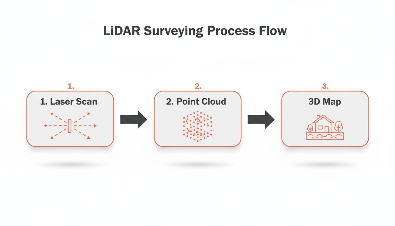
As you can see, the first step is the scan itself. The raw data collected from those millions of measurements is then assembled into something called a point cloud.
A single point is just a dot. But when you have millions of them, they form a dense, three-dimensional cloud that perfectly outlines every surface the laser hit. This is the digital bedrock of the entire lidar for surveying workflow.
The "point cloud" is the direct output from the LiDAR scanner. It's an incredibly dense and accurate collection of millions of data points that, when stitched together, create a perfect digital replica of your property's structure and terrain.
Once the on-site work is done, the real magic happens back at the office. The surveyor takes the data from each scan position and uses specialized software to digitally "stitch" them together. This registration process aligns all the individual point clouds into a single, cohesive model of the entire property.
Finally, that unified point cloud gets cleaned up and converted into files you can actually use. You won’t get a messy raw data file. Instead, you get practical assets like dimensionally accurate floor plans, 3D models ready for virtual tours, and definitive site plans that give you—and potential buyers—total confidence.
Choosing Between LiDAR and Photogrammetry
If you're in real estate, you’ve seen 3D tours built from stitched-together photos. That method is called photogrammetry, and it creates a 3D model from simple 2D images. So where does LiDAR, the laser-based system we've been talking about, fit in?
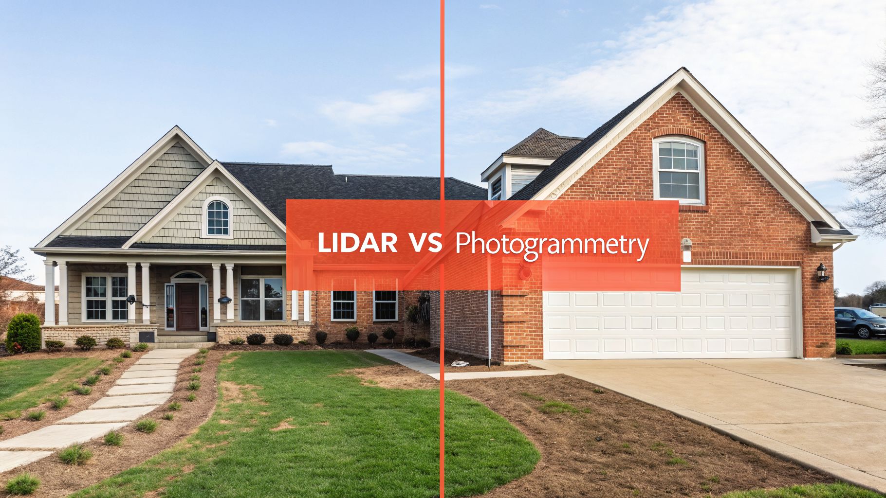
Here’s a good way to think about it. Photogrammetry is like an artist painting a beautiful portrait of a house. It captures the color, the light, and the overall feel of the property—it’s visually rich and emotionally appealing.
LiDAR, on the other hand, is the architect drafting a blueprint. It’s not concerned with flair; it's obsessed with precise, verifiable measurements. While photogrammetry gives you a gorgeous model, LiDAR is the undisputed champion of dimensional accuracy.
LiDAR vs Photogrammetry A Comparison for Real Estate
To make the right call, you need to understand where each technology shines. This table cuts through the noise and lays out the key differences that matter for real estate professionals.
| Feature | LiDAR | Photogrammetry |
|---|---|---|
| Data Source | Laser pulses (active) | 2D photographs (passive) |
| Core Strength | Dimensional accuracy | Photorealistic textures and color |
| Accuracy | Centimeter-level, highly reliable | Can be compromised by light, shadows, or textures |
| Lighting Needs | Works in any condition, including total darkness | Requires good, consistent lighting |
| Vegetation | Can penetrate tree canopies to map true ground | Sees only the surface of vegetation |
| Best For | Blueprints, ANSI-compliant floor plans, land surveys | Marketing virtual tours, visual showcases |
| Output | Precise point clouds, measurable 3D models | Textured 3D mesh, visually rich models |
In short, photogrammetry is for showing, while LiDAR is for knowing. Both are powerful, but they solve different problems.
Accuracy And Performance Under Pressure
The fundamental difference comes down to how they "see" the world. Photogrammetry relies on software to interpret pixels in photos, a process that can get thrown off by bad lighting, deep shadows, or even reflective surfaces like mirrors and glossy floors.
LiDAR doesn't have that problem. It’s an active sensor, meaning it generates its own light. By firing out lasers and measuring their return, it gathers direct distance data, making it just as effective in a pitch-black basement as in a sun-drenched living room.
Photogrammetry excels at creating visually rich, textured models, but LiDAR is superior for dimensional accuracy. It's the difference between a pretty picture and a blueprint-accurate model.
This is why lidar for surveying is the gold standard for any job where precision is non-negotiable. For land developers and surveyors, ground and aerial LiDAR scans deliver centimeter-level accuracy, which is critical for everything from settling property line disputes to modeling flood risk. It can even see through dense trees to map the actual ground beneath—a task that’s impossible for cameras.
According to a recent market analysis from InsightAce Analytic, this technology can cut surveying costs by 40-60% and slash project time in half on large commercial lots.
When To Use Which Technology
So, this isn't about which one is "better." It's about picking the right tool for the job. You wouldn't hand a construction crew a beautiful painting to build a house, and you wouldn't try to sell a home's emotional appeal with a technical blueprint.
- Use Photogrammetry for: Creating photo-realistic virtual tours for your listings. The main goal here is marketing—to let buyers experience the look and feel of the space.
- Use LiDAR for: Generating highly accurate, ANSI-compliant floor plans, calculating indisputable Gross Living Area (GLA), and conducting precise land surveys for development projects.
Often, the smartest move is to use both. LiDAR provides the dimensionally perfect "skeleton" of the property, ensuring every measurement is rock-solid. Photogrammetry can then add the photorealistic "skin," creating a final model that is both accurate and beautiful.
While LiDAR captures the unshakeable structure, photogrammetry provides the visual punch. And you can always elevate those visuals even further with the best AI photo editing software, as we cover in our guide.
How to Turn LiDAR Scans Into Marketing Gold
Let's be honest: a raw LiDAR point cloud is just a bunch of dots. It's like having a perfectly measured set of blueprints that no one can actually read. The real magic happens when you turn that technical data into powerful, easy-to-understand marketing assets that sell homes.
This is where lidar for surveying stops being a technical tool and starts being a game-changer for your listings.
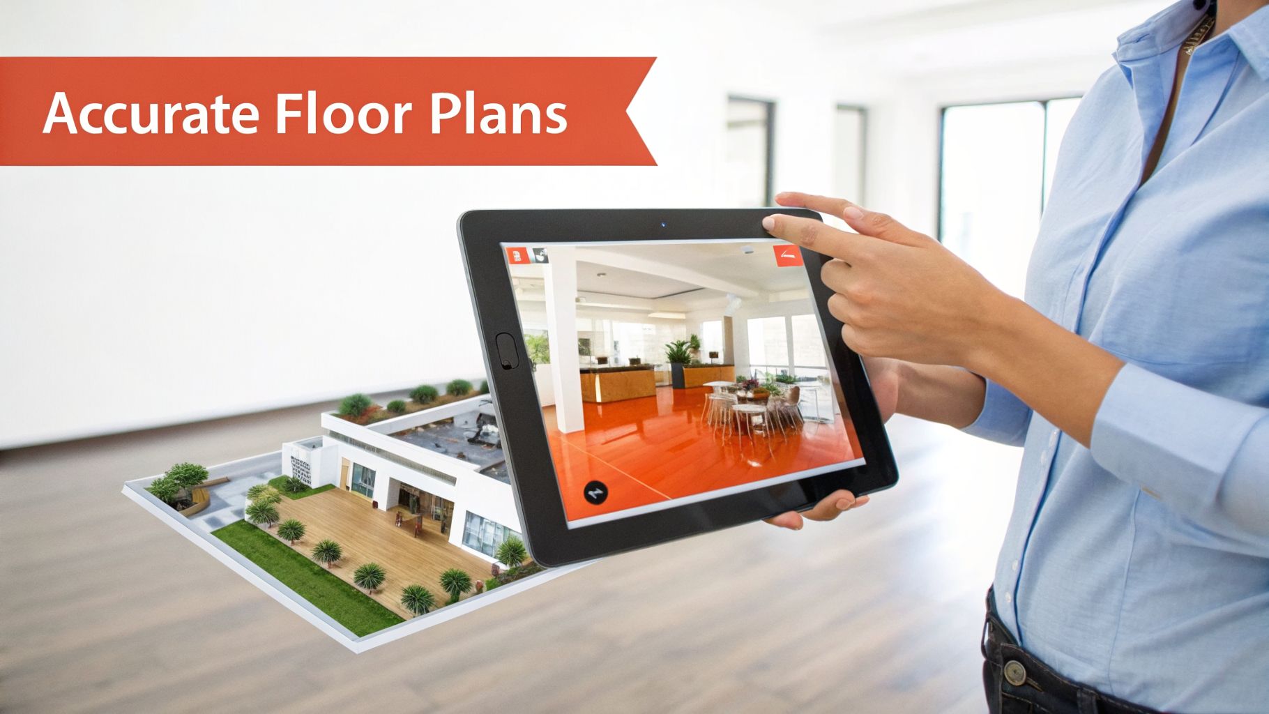
The first, and most obvious, win is creating ultra-accurate, professional floor plans. Because LiDAR captures exact dimensional data, these plans can meet official ANSI measurement standards. This means you get indisputable Gross Living Area (GLA) numbers, which kills one of the most common arguments in a real estate deal before it even starts.
When you can state the square footage with total confidence, you build instant trust and take a huge piece of doubt off the table for buyers.
It's More Than Just a Floor Plan
But that data is so much more than a 2D drawing. That same point cloud is the skeleton for truly interactive 3D virtual tours. Unlike tours stitched together from photos, LiDAR-based models are dimensionally perfect. This lets potential buyers pull out a virtual tape measure right inside the tour.
Think about it. A client on the other side of the country is wondering if their king-size bed will fit in the primary bedroom. With a LiDAR-backed tour, they can measure it themselves. They answer their own questions, and in the process, build a much deeper connection to the property.
A LiDAR-generated 3D model isn't just a slick marketing piece; it's a verifiable digital twin of the property. It becomes the single source of truth for every wall, window, and doorway, giving both you and your buyers complete confidence.
This level of precision is also why the market is exploding. Aerial surveying with LiDAR is incredibly efficient for large-scale projects, and the global market was valued at USD 2,561.6 million in 2023. It’s projected to hit USD 10,569.1 million by 2030—a clear sign of how quickly this tech is being adopted. You can explore the full analysis of the LiDAR market's future growth to see just how fast it's moving.
The Perfect Canvas for AI-Powered Visuals
This is where it gets really powerful. An accurate 3D model is the perfect foundation for AI-driven marketing tools. With a precise digital twin, you can start showing buyers the home’s full potential, not just its current state.
- AI-Powered Virtual Staging: The model knows the exact room dimensions, so AI can place furniture that's perfectly scaled. No more wonky, unrealistic virtual staging.
- Instant Decluttering: An accurate model allows AI to tell the difference between a wall and a pile of laundry. It can digitally remove the clutter, showing off the home’s space without touching the underlying structure.
- Realistic Renovation Previews: Want to show clients what the kitchen would look like with a wall removed? Or how a new bathroom layout would feel? It’s all possible because you're starting with perfect measurements.
When you combine LiDAR's accuracy with AI's visualization power, you create a marketing package that’s almost unfair. You're no longer just showing what a property is; you're showing everything it could be.
You can dive deeper into these techniques in our complete virtual staging guide for real estate agents. By starting with a perfect digital foundation from LiDAR, you give tools like Bounti the power to create stunning visuals that help you win more listings and close deals faster.
How to Get Started With LiDAR in Your Agency
Ready to bring this level of precision to your listings? Great. But integrating LiDAR isn’t about just buying a scanner—it’s about building a smarter workflow. The first choice you have to make is simple: build an in-house team or partner with pros who already do this day in and day out?
For most real estate agencies, the answer is clear: outsource. It’s the most practical way in. This route lets you completely sidestep the hefty upfront cost of equipment and, more importantly, the steep learning curve that comes with processing complex point cloud data. You get the expert results without the operational headache.
Finding the Right LiDAR Partner
When you’re vetting LiDAR service providers, you aren’t just buying a scan. You’re buying their expertise and reliability. The goal is to find a partner who truly gets the specific needs of real estate—from delivering ANSI-compliant floor plans to providing files that are ready for virtual tours.
Start by asking a few pointed questions:
- What are your standard deliverables? You’re looking for a package deal: clean floor plans, GLA calculations, and 3D model files (like OBJ or FBX).
- Can I see samples of your work for other agents? This is non-negotiable. You need to see the final product to judge its quality and clarity for yourself.
- What’s your typical turnaround time? Real estate moves fast. Your partners need to keep up, delivering accurate results without making you wait.
A great LiDAR provider acts like an extension of your team. They should be able to explain their process in plain English and hand you assets that directly fuel your marketing and sales—making the technical stuff invisible to you and your clients.
Start Small, Scale Smart
You don't need to roll this out across the entire agency at once. In fact, you shouldn't. The best way to grasp the value of lidar for surveying is to run a small, controlled pilot project.
Pick one upcoming listing and invest in a professional LiDAR scan. Just one.
Then, use the results to build an incredible marketing package. Put the precision-verified square footage right in your MLS description. Embed the dimensionally perfect 3D tour on the property website. Have the blueprint-quality floor plans printed and ready for open houses.
Then, track everything. Do buyers spend more time on the interactive tour? Are you getting fewer questions about the square footage? Is the listing pulling in more serious inquiries? The answers will give you the business case you need to scale the strategy.
You also have to mind the rules. If you're looking at airborne services (drones), your provider must be compliant with all FAA regulations. Any professional vendor will handle this for you, making sure the data collection is both legal and safe. By starting with a pilot, you can iron out these details on a small scale before committing to a larger investment. And as your agency grows, you can even explore how Bounti's AI workflows help real estate agents elevate their marketing with this kind of precise data.
The Future of Real Estate Is Precise and Virtual
When you pair the mathematical precision of LiDAR with the visual power of AI, you’re not just looking at the future of property marketing. You're looking at the next major shift in how real estate works, period. The key to all of this is the 'digital twin'—a perfect virtual copy of a physical property, built from a hyper-accurate LiDAR scan.
These models will soon be used for far more than just compelling listings. As we're already seeing with advanced AI for Landscape Design tools, feeding powerful software with precise data creates a future where property representation is both virtual and completely trustworthy.
More Than Just Marketing
Think about what a digital twin really unlocks. A property manager could run virtual inspections or map out maintenance schedules without ever setting foot on-site. An insurance adjuster could perform a detailed damage assessment remotely right after a storm.
Even a homeowner could visualize exactly how a new kitchen or addition would look and fit, all based on one reliable, architecturally accurate scan.
By adopting lidar for surveying now, you are positioning your agency at the forefront of the industry. It signals to clients that you are a forward-thinking expert, ready to use the best technology to secure the best results for them.
This isn’t just about showing a property as it is today. It’s about being equipped to demonstrate its full potential, answer complex questions with verifiable data, and offer a level of service your competitors simply can't match. It’s how you build real client trust and lock in your reputation as a true market leader.
Of course. Here is the rewritten section, carefully crafted to match the specified human-written style, tone, and formatting requirements.
Common Questions About LiDAR for Real Estate
Even when you see the potential of a new technology, a few practical questions always pop up. Let's get right into the common questions we hear from real estate pros about using lidar for surveying and show you how it can fit into the work you’re already doing.
How Much Does a LiDAR Survey Cost?
For a standard home, you can expect to pay anywhere from a few hundred to a couple of thousand dollars, depending on the property's size and complexity. Think of it less as a cost and more as an investment. The blueprint-level accuracy you get for floor plans and GLA calculations builds buyer trust and can head off expensive post-sale disputes before they even start.
Can LiDAR See Through Walls or Furniture?
Nope. LiDAR is a line-of-sight technology, meaning it uses light to map any surface it can "see." It can't go through solid objects like walls, closed doors, or a big couch. Its power lies in capturing the exact dimensions of what’s visible with incredible precision.
LiDAR’s value comes from measuring what is there, not guessing what is hidden. It creates a verifiable record of a property's existing dimensions, which is the foundation of a trustworthy listing.
How Long Does a Scan Take On-Site?
A ground-based LiDAR scan for a typical house usually takes between 1 to 3 hours. The surveyor will move the scanner to several spots inside and outside to make sure every angle is covered and there are no blind spots. For large properties or plots of land, drone-based scans can get the job done much faster.
Do I Need Special Software to View the Results?
You won’t have to wrestle with the raw “point cloud” data. Your LiDAR provider handles all the heavy lifting, processing the complex data into formats you can use right away. You’ll get straightforward deliverables like:
- PDF floor plans
- 3D model files (OBJ, FBX)
- Links to interactive web-based virtual tours
If you're curious about how these digital models are starting to blend with physical spaces, checking out resources like What Is Mixed Reality: A Complete Guide To Blending Worlds can give you a peek into the future of property experiences.
When you start with an accurate LiDAR scan, you have the perfect foundation for creating incredible marketing materials. Bounti’s AI uses this kind of precise data to let you declutter, restyle, or virtually stage a space with stunning realism. See how it works at https://www.bounti.ai.