Drone photography now earns its place in the marketing budget because buyers make faster decisions when they can see the full property story upfront.
For real estate, aerial photography drone services work best when they answer questions ground-level images cannot. They show how the home sits on the lot, what surrounds it, how the driveway and access points work, where the outdoor value really is, and whether nearby features help or hurt the sale. That clarity improves listing performance, but it also strengthens the agent's position in the listing appointment because the marketing plan is tied to buyer behavior, not gadget appeal.
I have seen the difference in two places. First, sellers respond better when the visual strategy is specific to the property instead of a standard photo package. Second, buyers arrive with fewer basic questions and a clearer sense of fit, which makes showings more productive.
That is only the starting point.
The optimal return comes from treating drone media as one part of a full workflow. The pilot has to be legal. The shot list has to match the property's selling points. The usage rights and deliverables have to be clear before takeoff. Then the finished assets need to feed into the rest of the campaign, including listing pages, social clips, email, paid ads, and AI-powered marketing systems such as Bounti that can turn one aerial shoot into multiple listing assets without wasting time or budget.
Why Drone Photography Is No Longer a Luxury
HomeJab found that listings with drone imagery can draw 94% more views, sell 68% faster, and in some cases command higher sale prices, while typical shoot costs stay relatively modest. That changes the budget conversation. Aerial photography drone services now belong in the standard marketing mix for any property where lot shape, setting, access, or surrounding features influence value.
The point is not to make a listing look expensive. The point is to remove uncertainty early, so the right buyers keep clicking, book showings, and arrive better qualified.

What Buyers Learn from Aerial Media
Aerial media answers questions that standard exterior photos leave unresolved.
- Lot use: Buyers can read parcel shape, yard depth, setbacks, and how much outdoor space is usable.
- Property context: They can see whether the home backs to water, green space, retail, traffic, or another factor that affects perceived value.
- Access: Driveways, gate placement, detached garages, guest parking, and entry routes make sense faster from above.
- Scale: Acreage, large rear yards, multifamily layouts, and commercial footprints are easier to judge in one frame.
That matters because listing traffic is a filtering process. Buyers decide quickly whether a property fits their needs. If your media leaves basic questions unanswered, they move on to the next tab.
Use a simple rule. If the sales pitch depends on land, orientation, privacy, approach, views, or neighborhood placement, drone coverage usually pays for itself.
The service category has matured
FactMR reports that the global drone photography services market was valued at USD 870 million in 2025 and is projected to reach USD 5.72 billion by 2036, with projected 2026 value of USD 1.03 billion and 18.7% CAGR, according to its drone photography services market report. For agents, the takeaway is straightforward. Sellers are seeing aerial media more often, and competing listing presentations increasingly include it as a baseline offer.
That shift affects perception before a property even hits the MLS. A listing package with no aerial plan can feel incomplete, especially for homes where exterior layout does real selling work.
Where agents miss the return
The biggest mistake is treating drone footage as a hero shot instead of a system.
A strong aerial package is built to support decisions. It should document boundaries, show the relationship between the house and the lot, highlight outdoor living areas, clarify nearby amenities or drawbacks, and produce assets that can be reused across the full campaign. That includes the listing page, social clips, email marketing, paid ads, and AI-assisted publishing tools.
Process begins to matter more than the aircraft itself. A legally captured aerial shoot with clear usage rights can feed multiple channels for weeks. Teams that want consistent output should also pay attention to how edited visuals are disclosed, especially as AI touches more listing media. Bounti's guide to California AB 723 and AI real estate photos is a useful reference point if your workflow includes enhancement, automation, or AI-generated marketing assets.
Agents do not need to become pilots, but they do need enough context to judge whether a vendor can protect the listing and support the campaign. If you want a plain-English primer on certification and commercial drone standards, TruTec's guide on winning more bids with drones is a practical place to start.
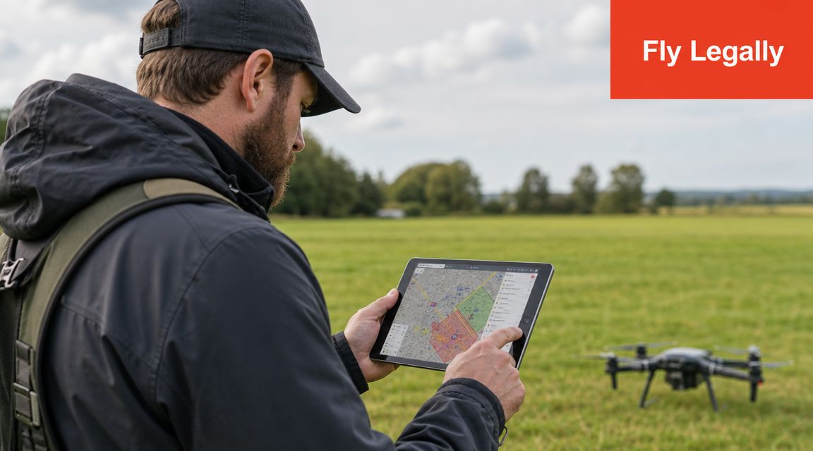
Navigating the Legal Airspace and Local Rules
Most agents don't need to become aviation experts. They do need a repeatable compliance checklist. If your vendor can't answer basic questions about licensing, insurance, flight restrictions, and permissions, you're not hiring a marketing partner. You're hiring risk.
Start with commercial pilot credentials
For paid real estate work in the U.S., the baseline requirement is a Part 107-certified pilot. That's the first thing to verify. Don't assume that someone with a nice Instagram portfolio is operating legally.
Ask for:
- Current commercial credentials: The pilot should be able to confirm they're authorized for commercial drone work.
- Proof of insurance: Liability coverage matters because you're flying around homes, cars, neighbors, and sometimes occupied commercial sites.
- Airspace planning process: If they can't explain how they check for restricted or controlled airspace, that's a problem.
If you want a plain-English overview of why certification matters when you're winning more bids with drones, that resource from TruTec is a useful primer for agents who want enough context to vet providers intelligently.
Hire the operator who can explain the flight plan, not just the camera specs.
Controlled airspace changes timelines
Aerial shoots in dense urban areas, near airports, or around sensitive sites can require more planning than a suburban listing with open airspace. That doesn't mean the job can't be done. It means turnaround, approvals, and scheduling may vary by property.
Agents often overpromise to sellers. A provider may advertise fast delivery, but the workflow still has to fit the site. Drone providers now promote 24-hour download availability and monthly construction progress tracking, while making clear that the operational standard, cadence, and output format need to match the property type, city rules, and sales cycle, as noted in the overview of drone deliverables and workflows.
That's especially relevant for mixed-use listings, active construction sites, downtown towers, and commercial parcels where access rules and surrounding flight constraints are more complicated than they look.
Local rules still matter
Federal flight rules aren't the only issue. Municipal restrictions, event-day restrictions, private community standards, and HOA concerns can all affect what's practical on site. On top of that, real estate teams also need to think about image compliance, editing disclosures, and how marketing visuals are presented.
If your team is already reviewing visual compliance policies, Bounti's explainer on California AB 723 and AI real estate photos is worth reading because it sharpens the broader habit agents need here: document what was captured, what was edited, and what's being represented.
Before flight day, confirm:
- Property access permissions
- Any community or building-specific restrictions
- Whether neighboring properties may appear prominently in the footage
- Expected delivery format and timeline
- Who is responsible if weather or approvals delay the shoot
A compliant workflow feels less exciting than a cinematic reel. It also prevents the kind of mistakes that derail launches, upset sellers, or expose the brokerage to avoidable issues.
A short visual refresher can help if your team needs to understand the basics of legal drone operations in real estate marketing.
How to Choose the Right Drone Service Provider
A crowded vendor pool creates a simple problem. More pilots are available, but usable real estate marketing work is still uneven.
The right provider does more than fly safely and capture a sharp image. They need to understand how buyers read a property from above, what details support the listing story, and what footage will be used across MLS, social, email, paid ads, and platforms like Bounti. If the deliverables do not fit your marketing system, the shoot becomes expensive decoration.
Look past the highlight reel
A polished portfolio can hide weak real estate judgment. Cinematic sunsets, fast reveal moves, and dramatic orbit shots may look good on Instagram, but they do not prove the pilot can market a narrow infill lot, a warehouse with truck access, or a family home on a busy road.
Review work that matches your listing type. A residential agent should ask for examples that show lot lines, backyard depth, privacy, and neighborhood context. A commercial team should look for frontage, access routes, parking count, signage visibility, and relation to nearby tenants or corridors.
Check for these signs of real competence:
- Real estate framing: Shots explain the asset instead of showing off drone movement.
- Altitude control: The pilot knows when to stay low for detail and when to go higher for context.
- Editing restraint: Colors look credible, edges are clean, and the property still resembles reality.
- Deliverable fit: Files are prepared for listing pages, vertical social clips, ads, and presentation decks, not just a single highlight video.
Ask questions that reveal how they work
The best vendors usually sound like operators, not artists chasing cool footage. They can explain scope, timing, revision limits, usage rights, file specs, and what happens if conditions change.
I use a short screening list because it gets to the point fast:
- What property types do you shoot every month?
- Which deliverables are included: stills, vertical clips, horizontal video, labeled map views, or raw files?
- How do you handle weather delays, airspace limits, or neighbor visibility concerns?
- Can you show before-and-after editing examples for a real estate listing?
- What usage rights come with the shoot, and can the media be reused in future campaigns?
- How do you name and organize files for marketing teams using platforms like Bounti or other listing workflows?
That last question matters more than many agents think. If your team has to rename files, resize video, and chase missing formats after every shoot, the cost of the vendor goes up fast.
Vet the provider like a listing partner
A drone pilot affects launch speed, brand credibility, and seller confidence. Treat the hire the same way you would treat a photographer, stager, or copywriter who touches the listing outcome.
| Red Flag 🚩 | Green Flag ✅ |
|---|---|
| Portfolio is mostly travel footage with little property work | Portfolio shows residential, land, and commercial examples built around marketing goals |
| Pricing is the main pitch | Scope, deliverables, usage rights, and timeline are explained clearly |
| Vague answers about approvals or restricted areas | Clear process for scheduling, contingencies, and site limitations |
| Heavy editing that misrepresents grass, sky, or lot lines | Clean edits that improve presentation without creating accuracy problems |
| Unclear file delivery | Specific output for MLS, social, web, and ad use |
| Same shot approach for every property | Shot selection changes based on lot size, product type, and buyer profile |
Price matters less than downstream usability
The cheapest quote often creates the most waste. Reshoots, missing formats, delayed delivery, and unusable clips can slow the listing launch and force your team to patch together assets at the last minute.
A strong aerial photography drone services provider helps you get a return because the work fits the full chain. Capture. Edit. Approve. Publish. Distribute. Feed the assets into your AI-assisted marketing workflow so they can be reused in listing pages, social campaigns, seller reports, and follow-up promotion without extra cleanup.
That is the standard to hire against.
Planning the Shoot From Shot List to Contract
Most weak drone shoots fail on the ground, not in the air. The property isn't ready, the shot list is generic, the seller hasn't cleared vehicles or clutter, and nobody decided what the footage needs to accomplish. If you want measurable return, planning has to start with the listing strategy.
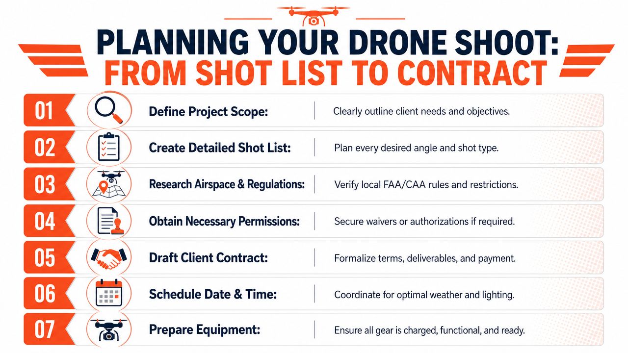
Build a story-driven shot list
A drone pilot can capture beautiful angles all day and still miss the selling point. Your shot list should answer one question first: what is the property trying to prove?
For a residential listing, that may be privacy, yard depth, water adjacency, a pool layout, or how the house sits on the lot. For commercial property, it may be access, parking, frontage, visibility, loading, neighboring tenancy, or site scale.
A useful shot list usually includes:
- Hero angle of the full property from a height that establishes the site without making the structure disappear.
- Approach view that shows entry sequence, driveway, frontage, or parking access.
- Backyard or amenity perspective for pools, patios, detached structures, sport courts, or waterfront edges.
- Context frame that shows relation to key surroundings if those surroundings help the sale.
- Boundary-supporting visuals where legal and appropriate, especially for larger parcels.
Don't force drones where they don't help
One of the most under-discussed points in property marketing is that drones are not always the whole answer. Red Wing Aerials offers the most grounded version of this: drones are strong for low-altitude detail, while manned aircraft can be better for broader location context such as highways, schools, and nearby retail, and some properties are best served by a mix of aircraft, drone, and ground photography, as explained in its guidance on choosing the right aerial format.
That's exactly right in practice.
A downtown condo may need street-level energy and interior lifestyle imagery more than aerial coverage. A rural estate may need all three formats because buyers need to understand both immediate features and regional context. The right question isn't “Should I add drone?” It's “What camera position tells this property's story best?”
If the aerial image doesn't answer a buyer question, it's just decoration.
Tighten the contract before the shoot
Good preproduction also means getting the paperwork right. The contract should remove ambiguity before anyone schedules batteries, pilots, and sellers.
Check for these terms:
- Usage rights: Confirm whether your brokerage can reuse images in listing promotions, future presentations, and social campaigns.
- Deliverable list: Number of edited stills, video clips if any, orientation options, and file formats.
- Turnaround expectations: Define when files arrive and what happens if weather forces a delay.
- Reshoot policy: Clarify whether a reshoot is included if cars, weather, or property readiness affect the result.
- Property prep responsibilities: State who handles staging, vehicle removal, outdoor cleanup, and access.
The most effective shoots look simple on site because someone made the hard decisions in advance. That's what turns aerial photography drone services into a repeatable listing system instead of a one-off creative experiment.
Integrating Drone Assets Into Your Marketing Workflow
Getting the files back is the midpoint, not the finish line. Raw aerial media only creates value when it's turned into listing assets buyers consume. That means choosing the right stills, matching them to the right channels, and building consistent outputs fast enough that your launch window stays tight.
Turn one flight into multiple assets
A single aerial session can feed several marketing needs if you organize it correctly. Organizations often underuse what they paid for because they treat the drone folder like archive material instead of campaign fuel.
Use the assets in layers:
- MLS-ready stills: Select the clearest overhead and oblique images that help explain the property.
- Website gallery placement: Put aerials where they support the narrative, not as a random block at the end.
- Social clips: Pull short, clean movement shots for listing teasers and neighborhood context posts.
- Presentation material: Reuse top aerials in listing pitches, property brochures, and seller updates.
That workflow matters because different platforms reward different formats. MLS usually needs restraint and clarity. Social rewards motion and strong first-frame composition. Listing presentations benefit from before-and-after comparisons that show how your marketing package rises above the market norm.

Use AI to reduce production drag
The practical opportunity now isn't just better capture. It's faster repurposing.
Agents and marketing coordinators can use AI-powered editing and content workflows to pull still frames from fly-by footage, prep image variants for different channels, and generate copy that references what the aerials show, such as lot depth, proximity to water, outdoor entertaining space, or access points. That shortens the gap between media delivery and campaign launch.
If your team is comparing editing workflows, this guide to AI photo editing software for real estate is a useful reference point for understanding which tasks can be automated and which still need human review.
Match the asset to the selling point
Strategy triumphs over volume. Don't dump every drone still into the listing.
Use aerials when they do one of these jobs well:
- Show land value: Corner lots, acreage, outbuildings, and outdoor amenities.
- Show environmental advantage: Water, mountain, golf, park, trail, or greenbelt adjacency.
- Show commercial practicality: Traffic access, parking fields, building orientation, nearby anchors.
- Show development potential: Vacant or underused sites where buyers need spatial context.
Skip aerial overload when the property's strongest case is interior finish, walkability, or street-level character. In those cases, one or two supporting drone images can be enough.
Buyers don't need every angle. They need the angle that resolves uncertainty.
The best marketing workflows treat drone media as one input in a larger production system. Once the files are tagged, trimmed, and distributed correctly, aerial photography drone services stop being a standalone line item and start functioning like a reusable content engine.
Your Blueprint for High-Altitude Marketing Success
The agents who get the best return from drone media don't treat it like an occasional upgrade. They treat it like a decision framework.
Use aerial photography drone services when the property's value is easier to understand from above. Vet providers like vendors, not artists alone. Require legal and operational clarity. Plan the shoot around buyer questions, not generic beauty shots. Then move the finished assets into a marketing workflow that can support MLS, web, social, and listing presentations without creating more manual work for your team.
The broader commercial backdrop supports that approach. Fortune Business Insights estimates the global drone services market at USD 32.08 billion in 2025, with North America holding 34.64% of that market, according to its drone services market analysis. For agents in the U.S. and Canada, that matters because it confirms where commercial drone adoption is most concentrated. This isn't fringe marketing anymore. It's established business infrastructure in the markets where competition is sharpest.
The operating model that works
The cleanest system looks like this:
- Choose selectively: Use aerials where they clarify value, not by default on every listing.
- Standardize vendor review: Keep a checklist for credentials, insurance, scope, and deliverables.
- Pre-plan every shoot: Tie the shot list to the property's strongest selling points.
- Repurpose aggressively: Convert one flight into stills, clips, and presentation assets.
- Measure results: Track views, inquiries, showing quality, and seller feedback after launch.
For teams trying to distribute media more effectively after launch, Bounti's guide to real estate social media marketing is a practical next read because social placement is often where aerial content either compounds value or gets wasted.
Aerial media won't fix weak pricing, poor property prep, or thin positioning. It will make a strong listing package more persuasive, more memorable, and easier for buyers to understand quickly. That's why the return is real when the workflow is disciplined.
Bounti Labs helps real estate teams turn property media into finished marketing much faster. With Bounti Labs, you can generate listing descriptions, pull stills from video, create MLS-ready visuals, and transform spaces with AI-powered decluttering, staging, restyling, or renovation concepts, all from a simple property walkthrough. If you want your media workflow to move as fast as your deals do, Bounti is worth a look.